CIL demonstrated drone procured by CMPDI
The high-resolution optical cameras on-board the drone will be used for generating optical images of high-resolution, which will be very useful for the generation of orthophoto mosaic for areas of plantation studies, settlement mapping, and various other applications.
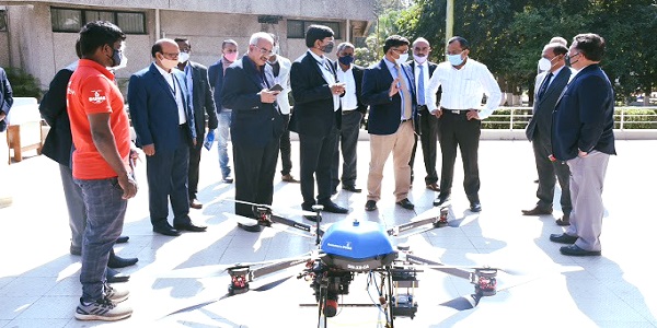
Shri. Pramod Agrawal, Chairman, CIL witnessing a live demonstration of the first drone procured by CMPDI at Ranchi (PSU Connect)
Ranchi: Shri. Pramod Agrawal, Chairman, CIL witnessed a live demonstration of the first drone procured by Central Mine Planning & Design Institute (CMPDI) at Ranchi.
Drones will be used by CMPDI for volumetric measurements in case of in-situ excavation, overburden dumps & coal stocks using its LiDAR sensors. LiDAR sensors can also be used for tree height estimation, vegetation assessment, and accurate terrain mapping besides indicating various other parameters. The thermal sensors on the Drones (which will be supplied with the second unit) will be used for the detection of spots of underground coal mine fire, flaw detection, etc.
By using drone-based sensors, it would be possible to generate 20cm resolution thermal data which can be very helpful to accurately detect spots where underground coal mine fire exists through mapping of a thermal anomaly. The high-resolution optical cameras on-board the drone will be used for generating optical images of high-resolution, which will be very useful for the generation of orthophoto mosaic for areas of plantation studies, settlement mapping, and various other applications.
Read Also : Vice Admiral Dinesh Kumar Tripathi appointed as next Chief of the Naval StaffNews Must Read
- CIL’s capex up 6.5% to highest Rs.19,840 Crores in FY 2024
- SCOPE presents SCOPE PREMIER LEAGUE
- MCL Ib Valley Washery commenced commercial operation
- HAL bags Rs 65,000 Cr tender by Defence Ministry
- PSBs' growth output superseded Private Lending firms
- Northern Coalfields Limited CMD inspects Amlohri Area
- SCOPE organizes Public Sector Day celebrations
- IOCL Final Dividend Announcement Expected at April 30 Board Meeting
- Steel Cutting Ceremony of Indian Navy held at HSL Vishakapatnam
- DIPAM declines PFC-REC debt resolution proposal for KSK Mahanadi project